Showing posts with label maps. Show all posts

Sunday, November 27, 2016

Amazons on a map

While reviewing some of the illustrated maps I used for the book, I've taken to hunting for Amazons. This group is on the Pierre Desceliers 1550 map of the world. The map was probably commissioned as a gift for Henry II of France.


Amazons
Above is the illustration of a thing worthy of memory and of being described, that is, strange and barbarous women who are experts at war and who are called Amazons. They number about 200 million, alone without men for some time. When they return victorious from battle, they are loved by their husbands with whom they go only once a year, and only to have children. If they have a son, they nourish him for six months and then give him to his father; if it's a daughter, they keep and raise her to train in feats of arms.

According to map historian Chet van Duzer, the text likely comes from an edition of Ptolemy's Geography published earlier that century (he mentions four possible contenders). As was the case with illustrated maps of that century, the placement of decorations on Descelier's wasn't random. Mapmakers were trying to make sense of a new discoveries coming in every day. Monsters, new animals, foreign monarchs, and historical events were placed in their approximate correct locations.

The Amazon army on this map is shown north of the Caspian Sea marching westward toward "Region de Mithridates." This mangles two Amazon legends together and mis-locates the kingdom of Mithridates, but he deserves points for trying. He is attempting to make sense of contradictory ancient sources and integrate them with new discoveries. Central and Northeastern Asia, despite bordering the Old World civilizations remain badly understood for another two centuries.

NOTE: I earlier wrote about this map and my reasons for studying it here.

Monday, October 3, 2016

Where are you going little ship full of wolves?

Olaus Magnus' 1539 map of Scandinavia, the Baltic Sea, and the North Atlantic, entitled the Carta Marina is a milestone of European cartography. At the time, it was by far the most accurate map of the region that had ever been made. Along with the correct geographic details and placements of human settlements, Magnus covered the map with hundreds of drawings of human history, ethnography, and natural history. Sixteen years later, he published a book expanding on those topics, entitled Historia de gentibus septentrionalibus (History of the Northern Peoples). For the book, he prepared 481 woodcut illustrations (including some duplicates). Of the illustrations, 124 are adapted directly from the map while many others include elements from the map.

Unfortunately, many interesting illustrations from the map didn't make it into the book. We have no way of knowing what they indicate. Other illustrations, prepared for the book, don't always match the text of the chapters they've been paired with. I'm working on a couple of blog posts about strong women in the Historia. While I do that, let me share some of my favorite illustrations.

Before I offer the first illustration, let me make my excuses. Although he was Swedish, Magnus wrote his book in Latin. At the time, there weren't even that many Swedes who wrote and read Swedish, and he was a Catholic priest. I can bludgeon my way through Latin well enough to get the gist of a text, but I'm not going to spend a whole afternoon to get a clean literary translation for the caption to a picture only a few dozen people are going to look at (unless I really like the picture). Next, the good commentary on his illustrations appears to be primarily A) in Swedish and B) not online. I might be horribly wrong in my interpretations of the illustrations. I hope that makes them more fun to look at.

Here are the wolves:


They are sailing eastward across the Baltic south of the island of Gotland and parallel to an ice-bound Polish coast. I believe the indication of ice-bound waters was an innovation of this map. Their eagerly anticipated goal appears to be in the neighborhood of Memel, Prussia, now in Lithuania.

But, are they wolves? I checked all of the illustrations in the Historia looking for boats in the Baltic Sea, both for this story and another. I found another illustration, set farther north in the Baltic Sea, that is intriguing, puzzling, and tragic all at once.

The title of the chapter is "About horses of Sveica and Gothica, why they are preferred to others, and exported." The illustration shows a barefoot man on the shore. Next to him is a large horse. He holds one arm up, with the forefinger extended above the horse. The other arm is extended downward at a tied-up ship full of animals (they resemble my wolves, but are they horses?) who look away from him. Another boat is still at sea in the upper right corner filled with animals that have ears and horns (goats? How many animals are sailing around the Baltic? This question will come up later). The bottom right quarter is filled with a disturbing vignette of two or three horses at sea, trying to climb onto icefloes.


The chapter explains that the horses Sveica and Gothica [the core provinces of Sweden] are in demand for export, but that there is a royal edict against selling warhorses. Do the horse, the man, and the boat full of animals represent an honest trader dividing superior war-quality horses from shamed exportable horses? This is followed by a lot of text demonstrating how much they love their horses, including a poem. He then mentions the lively horses of the island of Oelandiæ (Elandia on the map, Öland in modern Sweden). He says they are lively and ready for action and then something about dancing dogs that I haven't properly translated. In this case, are we looking at a well trained troop of performing animals? The dog/wolves are looking away because they are waiting for their cue. This is not as crazy as it sounds. There will be other animals on boats.

So, who are the sly animals on the boat?

Note: Online you can find many images taken from the less detailed second edition of the Carta Marina. There are only two copies of the first edition that have survived. This is the map I'm using for all my posts. The book, the Historia, was translated and reprinted many times. For my images and my text, I'm using the first, Latin edition from this site. If you write about this, please link and credit carefully.

Wednesday, June 10, 2015

The White Elephant of Rucheni

On a Renaissance map of the world, there is a small white elephant standing near the Arctic coast of Russia. How it got there is a mystery. Is it a mammoth, or does it symbolize something else? The solution is like a jigsaw puzzle. We have many pieces of evidence, in different colors and shapes. But it's not clear that all of the pieces belong to the same puzzle and, in any case, too few pieces have survived for us to be able to construct a clear image of the thinking that led the artist to place that elephant in the frozen north. Perhaps the most important clue that we have to work with is that the elephant occupies a position that mapmakers had previously reserved for a monster that we now call the walrus.

The Dieppe school is the name given to a group of cartographers who worked, predictably, around Dieppe, France and who produced maps during the middle decades of the sixteenth century. Most of the Dieppe maps are large, hand-drawn, decorative maps produced for rich patrons. The maps are not useful for any practical purpose, such as sea navigation or invading the Netherlands, but they are very accurate and up to date for their times. Their real purpose was to inform kings and courts about the latest discoveries in other parts of the world.


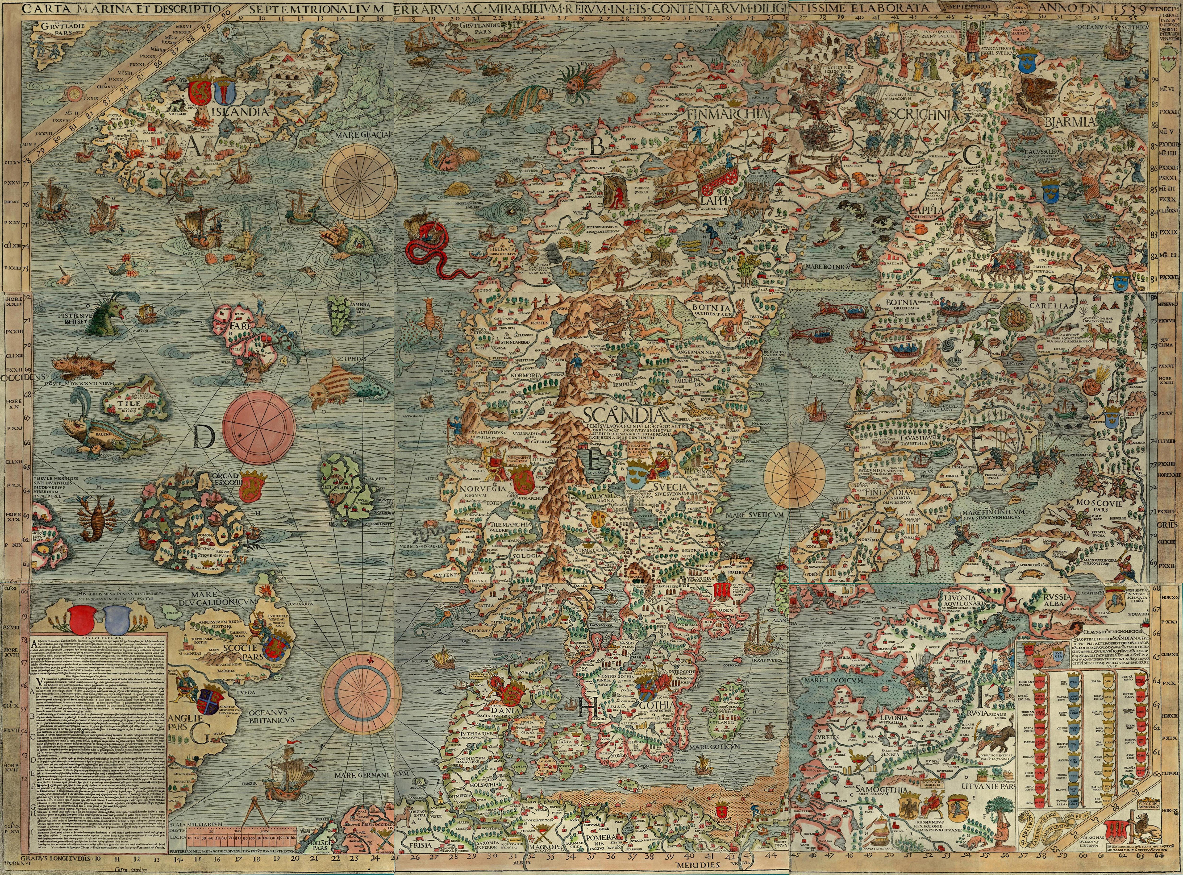
The Desceliers map of 1550. (source)

The world map signed by Pierre Desceliers and dated 1550 is a perfect example this type of map. It is large, 135 cm x 215 cm. It was clearly meant to be read spread out on a table rather that hung on a wall. When looking at the map from the South, the text in the Southern hemisphere is right-side up, half way across the map, the text suddenly flips so that the Northern Hemisphere reads correctly for someone on the other side of the table. The map has notes scattered about it describing distant lands and recent discoveries. It is beautifully decorated with color illustrations of real and mythical animals, peoples, and cities. It carries the coat of arms of kingdom of France and was probably made for King Henri II.

For the last hundred and fifty years, two opposite corners of the map have attracted the most attention from scholars. In the Northwest, Canadian historians study this map and the other Dieppe maps because they were the first to display information gained from the voyages of Jacques Cartier and Jean-François Roberval. These maps were the first to show the Gulf of St Lawrence and a mostly correct shape for Newfoundland. In the Southeast, the map shows a great landmass with some Portuguese place names on it separated from Java by a narrow channel. On other Dieppe maps, this land is called Java la Grande. To many, this appears to be evidence that the Portuguese knew about Australia long before its official discovery by the Dutch in 1606.


Canadian bears at lunch.


Dog-headed men sacrifice one of their own in Java la Grande.

There are other fascinating details on the map, but for mammoth researchers, the most interesting detail is on the north side, just west of center. There, in what corresponds to Northwestern Russia, is the elephant. That part of the map is twisted ninety degrees counter-clockwise so that Russia's European Arctic coast runs straight north from Scandinavia instead of east. Although it is very close to France and Germany, very little was known about Scandinavia by continental mapmakers at the time. However, there are enough details and place names on the map for us to be sure where the elephant is meant to be.


Desceliers Arctic elephant. North is at the bottom of the page.

In the detail above, Scandinavia is at the top of the map. "Sveti" (the word that looks like "Sulti") is Sweden. The embayment just below it is the Gulf of Bothnia, part of the Baltic Sea. The embayment below that, to the left of the word "Finland," and entering from the West (right), is the White Sea. "Groullande" means Greenland. Why it's in Russia is a story for another day. Below that, next to a vacant native village, are a bear, some kind of deer, and a white elephant.

This scene is more than a decoration; the animals are supposed to be representative of the native fauna of that region. Other real animals on the map are in the same approximate locations where they would have been found in life. Mythical animals are in the correct places where the myths place them. There are other elephants on the map in central Africa, Persia, at the court of the Chinese emperor, and in Java la Grande (next to a description of Sumatra). Desceliers appears to have known the difference between Asian and African elephants. In his illustrations, the latter are bigger, have larger tusks, and larger ears (though he did give them Basset hound ears). And, in case there was any doubt, the legend specifically mentions elephants in Russia.


Desceliers description of Russia. (source)

In a text box to the right of the elephant, Desceliers describes Russia:
Near the north pole is a country and people called Rucheni and they confess in the manner of the Greeks. They are beautiful and blonde, dependent on sleighs, and have silver mines. Their merchandise consists of valuable pelts, falcons, gyrfalcons, white elephants [ylefanz blanc], bears, moose and others that they carry to other parts of the world. The region is very cold; the land is known as the glacial. It is continuous day for six months, when the sun is above the equator, and for another six months it is night, when it is the on the opposite side.
The obvious questions, at this point, are: Could Desceliers' white elephant be a reference to the mammoth and, if not, what else could it be? Unfortunately, the answer is not as simple as "well, of course it's a mammoth." Most people are familiar with the fact that mammoth bones, ivory, and, occasionally, complete carcasses of mammoths are found in Arctic Russia. In fact, mammoth ivory currently makes up a significant portion of the global ivory trade. How big a portion is impossible to determine, since most of the trade is illegal. But no mammoth remains have been found around the White Sea; it was still covered with glacial ice when mammoths died out in Europe. The prime region for collecting mammoth ivory begins two thousand miles to the East in Siberia. Still, there is a way that mammoth ivory could have been traded there.

The White Sea is at the end of a long system of trade routes that extend along the coast and deep into Siberia using small, shore hugging boats and the great northern river systems. The first known historical accounts that unambiguously mention Siberian mammoth ivory all are in the context of trade along this coast.

In 1611, Josias Logan, the representative of the British Moscovy Company at Pechora, on the European side of the Urals wrote, in a letter to Richard Hakluyt, "There use to come hither in the Winter about two thousand Samoieds with their Commodities, which may be such as we dreamed not on yet. For by chance one came to us with a piece of an Elephants Tooth... ." Logan thought the ivory meant that there was an easy way across Siberia to China, because that was the closest place he thought elephants could be found.

Eight years later, Richard James sailed to Russia as chaplain on a diplomatic mission to Moscow. The mission was a failure; James missed the ship back to England and ended up spending winter in Kholmogory on the White Sea. He kept a small journal in which he wrote new words that interested him. On page 62, following the word for elephant (slone), he wrote: "maimanto, as they say, a sea Elephant, which is never seene, but according to the Samites, he workes himself under grownde and so they find his teeth or hornes or bones in Pechare and Nova Zemla." Sea elephant was sometimes used as a synonym for walrus, but James had already made a separate entry for walrus (mors), so he clearly meant that maimanto was a different elephant-like creature.

Logan and James both observed elephant (mammoth) ivory in the hands of Samoyeds (now called Nenets), a people whose territory extended across the Arctic coast from the White Sea to the Urals and beyond, covering a large part of the trade route that would have brought mammoth ivory to Europe. From Kholmogory, where James saw ivory with the name mammoth (maimanto), to the mouth of the Pechora, where Logan saw what he called an elephant's tooth, is about four hundred miles. The trade route from Pechora across the Urals to the Gulf of Ob is another six hundred miles. From there to the region where most mammoth ivory is collected, on the Eastern side of the Tamyr Peninsula, is another thousand miles. How did mammoth ivory enter into such a long trade route? Given enough time, any valuable commodity will find its way to market.
At the western end of the trade route that brought mammoth ivory to Pechora and Kholmogory was a market that was that already demanded ivory. For centuries, this demand had been satisfied by walrus ivory. Over time, the western walrus herds were driven to near extinction and hunters and merchants moved further afield looking for new sources of ivory. As they  worked their way east, word of their desire for ivory and their willingness to pay for it with good iron tools would have moved east ahead of them into the mammoth regions.

Sometime before the year 890, a Viking named Othere, looking for new trade opportunities, showed up at the court of King Alfred of Wessex, who was busy uniting England at the time and would later be known as "the Great." Hoping perhaps to impress his host, Othere bragged of his wealth, his lands, and his travels. Othere was a lord in Hålogaland, the northernmost settlement of the Norwegians as he described it. Othere gave Alfred some walrus tusks and told him where he acquired them. "He said that on one occasion he wished to find out how far that land extended due north or whether anyone lived north of the waste...." Othere described sailing north for three days, east for three days, and finally south for five days. There he stopped at the mouth of a great river. North, east, and south from Hålogaland would have taken him around North Cape and the Kola Peninsula and deep into the White Sea. The largest river entering the White Sea is the Northern Dvina. At its mouth is the site where Kholmogory would later be built. At this point in his story he admits, "He traveled there chiefly - in addition to observing the land - for the walruses (horshwælum), because they have very fine bone in their teeth." Othere knew there was walrus ivory in the Northeast before he made his voyage, possibly from the Finnish tribes that paid him tribute. The implication of his story is that he made his journey to see if he could cut out the middleman and acquire ivory directly.

Othere's tale, which tradition says was written down by Alfred himself, shows that almost seven hundred years before Desceliers drew his map, Europeans were traveling to the White Sea, specifically to look for ivory. From that date forward, there are plenty of accounts of ivory being traded across the Russian lands into Europe, Central Asia, the Middle East, and the Mediterranean. In the eleventh century, the Persian polymath al Biruni wrote that the Volga Bulgars "bring from the northern sea teeth of a fish over a cubit long. White knife hafts are sawed out of them for the cutlers." In 1207, during one of their frequent uprisings, the people of Novgorod evicted their prince and each of the rebels took as their booty three coins and a walrus tusk. In 1476, one of those same Novgorodians presented a tusk to their new ruler, Ivan III of Moscow. In 1527, envoys from Moldova demanded free passage across Poland-Lithuania to Russia so they could "acquire furs and fish teeth to pay tribute to the Turks." By the early sixteenth century, walrus ivory had appeared everywhere that ivory was imported.

This is not to say that walrus ivory was recognized as such everywhere that it was imported. The trade routes that brought elephant ivory from Asia and Africa and walrus ivory from Greenland, Iceland, and northern Eurasia were long and involved, with the ivory changing hands many times before it reached its final consumers. Europe, in 1500, was in the midst of a poison panic. Unicorn horn was the only known protection against poisons and upper class Europeans would pay any price for genuine unicorn horn. In those pre-FDA days there was no quality control for magical anti-poison artifacts. The market responded to the demand by providing buyers with elephant ivory, walrus ivory, narwhal horn, old bones, random teeth, and even interestingly shaped white rocks, all of which were guaranteed to be authentic unicorn horn. In such an atmosphere it was only natural that there would be some confusion about the nature of the animals that supplied ivory.

Before 1500, Europeans had only the vaguest idea what an elephant actually looked like and no idea what a walrus looked like. There are records of only two elephants have been seen in Europe between the fall of the Roman Empire and the middle of the Renaissance. The artist who illustrated the Anne Walshe bestiary in the early fifteenth century might have been able to find some images of elephants in older illustrated manuscripts or descriptions from recent travelers. Instead, he pieced together an animal based entirely on classical texts. The accompanying, seven sentence description, uses information from the earlier bestiaries of Physiologus, Solinus, and St. Ambrose, all sources over a thousand years old at that time. The illustration gets some things right. The elephant is large, grey, and boxy. It has a trunk and tusks. But it has too many tusks—four. It also has tiny ears and hoofed feet. Like most medieval bestiaries, his follows a classical canon of animals known to Roman writers. It does not include any animals of the far north, such as moose, polar bears, or walruses.


Elephant from the Anne Walshe bestiary, early 1400s. (source)

The earliest European illustrations of walruses begin to appear after 1500 and are based on even less information than the Walshe elephant. The most influential of these illustrations came from Olaus Magnus, the last catholic bishop of Upsalla, Sweden. In 1539, Olaus published a colorful map of the northern Atlantic filled with ships and delightful monsters. But his monsters were not there just to fill space. Olaus was able to cite sources for most of the animals and dramatic scenes on his map. In 1555, he published 
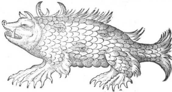
Historia de Gentibus Septentrionalibus, a lavishly illustrated book on the people of the north that included descriptions of the animals and monsters depicted on his map. Olaus placed his walrus near the White Sea in roughly the same location as Desceliers' white elephant. He described the animal in this way: "To the far North, on the coast of Norway, there lives a mighty fish, as big as an elephant, called morse or rosmari ...." His walrus had legs and tusks in its lower jaw, like a wild boar. He also noted that it climbed mountains.


Olaus Magnus' rosmarus piscis (walrus fish) being tormented by snowball throwing Finns. From his 1539 map. (source)


Olaus Magnus' morso Norvagico (Norwegian walrus) about to be skinned by whalers. From his 1555 book Historia de Gentibus Septentrionalibus. (source)

Olaus' illustrations and descriptions carried a certain weight of authority; he came from a family of respected thinkers and had actually been further north than anyone else in the community of European thinkers. When writing the first edition of Historiae animalium (1551–1558), a work sometimes called the first work of modern zoology, Conrad Gesner relied heavily on Olaus' descriptions of marine animals. Olaus' Historia was translated into several European languages and republished many times over the next century. Even though somewhat more accurate information about walruses had been circulating since the 1520s, Olaus' images continued to influence concepts of the animal well into the next century. But if Olaus' readers thought his travels in the North had given him firsthand knowledge of walruses, they were mistaken. Olaus' written description of the walrus is based on a thirteenth century description of walrus hunting by Albertus Magnus and on two recent travelers to Russia who themselves repeated part of Albertus' description, adding only that walrus ivory was an important export commodity for Muscovy.

Olaus was not the first to repeat Albertus' description of walrus hunting—which involved slipping a rope through a cut in their skin while they slept on rocks, tying the end of the rope to a tree, awakening them, and allowing the frightened walruses to run out of their own skin in their rush to get back to the sea. Besides the two travelers Olaus mentioned by name (Maciej z Miechowa, 1517, and Paolo Giovio, 1525), at least two other writers had repeated the tale before him, Hector Boece (1526) and Sigismund von Herberstein (written in the 1520s but not published until 1549). Of these writers, only Herberstein mentions legs ("It has short feet, like those of a beaver"). Albertus described the walrus as a type of whale and, since whales were classified as fish during the Middle Ages and Renaissance, it should have been doubly clear that walruses should not have feet or legs. When Albertus described walruses climbing up on rocks to sleep, he clearly stated that they used their tusks to pull themselves up. Olaus repeated that detail. This raises the question, why did Olaus draw his walrus with feet and thick legs?

It should be easy to dismiss the legs as an imaginative flourish, but the work of another mapmaker suggests that Olaus might have had an unmentioned source that did mention legs. Like Desceliers, Martin Waldseemüller is best known for something other than his Arctic elephants. His 1507 map of the world was the first to use the word "America" to describe the new world. With such a claim to fame, it's not surprising that first thing most writers say about his next world map, the Carte Marina of 1516, is that it does not use the word "America." But, like Desceliers' map, there are plenty of other interesting details on this map that merit our attention. One of them is a strange, large creature in the far North.


Waldseemüller's morsus, 1516. (source)

The legend next to the animal reads:
The walrus (morsus) is an elephant sized animal with two long, quadrangular teeth. It is hindered by a lack of joints. The animal is found on promontories in Northern Norway where it moves in great herds.
Whoever drew the animals for Waldseemüller's map (possibly Albrecht Dürer) had more in mind than just an elephant-sized animal. What they drew is a very elephant-like animal. The body shape is passable for an elephant, as are the fan-shaped ears and longer legs than those on Olaus' morse. Less elephant-like are the hooves, lack of trunk, and boar's tusks. A second edition of Waldseemüller's map was made six years later by Laurent Fries. Fries produced a less expensive and smaller map that, while being much less detailed than the Carte Marina, retained the walrus and its description. Fries moved the morsus west of Greenland and made it more elephant-like by adding a trunk, though the hooves and boar's tusks remained.


Fries version of Waldseemüller's morsus. Fries map would go through several editions in the 1520s and 30s. (source)

Albertus' description compared the walrus' teeth to those of an elephant or boar. This was probably his way of saying that the teeth in question were tusks and not ordinary teeth. This mention could have been responsible both for the sixteenth century artists consistently putting the tusks in the walrus' jaw, boar style, and for the elephantish shape to its body. However, there is one strong clue that the elephant-ness of Waldseemüller's walrus was more than a suggestion planted in his artist's mind by Albertus using the word "elephant." That clue is Waldseemüller's mention in his description that the morsus has no joints. Ancient and Medieval scholarship is filled with authoritative statements that the elephant has no knees and sleeps standing up. Aristotle himself tried to debunk the legend, but was generally ignored on this point for the next two thousand years.

How did an animal that is basically a giant seal with fangs turn into a four-footed animal that invited comparison with an elephant? Did Waldseemüller and Olaus have unnamed sources that gave some additional anatomical details that sounded more elephant-like than seal-like? Unless we discover some amazingly detailed secret diaries, we will never know for sure if they had some unwritten sources or what those informants might have told them about walruses. We can, however engage in some logical speculation.

In a series of papers written in the first quarter of the last century, Berthold Laufer documented the history of walrus and narwhal ivory importation into China. He found accounts of ivory being traded down the Pacific coast from the far north as early as the fourth century AD. As a side note, he also described the ivory trade in Central Asia, the landward side of China. Laufer was strongly against the idea that any of the Pacific ivory was from mammoths, but grudgingly admitted that it might have been present in the Central Asian trade. He made very clear that the Chinese had no idea what kind of animal produced northern ivory. They generically called it ku-tu, a word which eventually made its way into Persian and Arabic. Laufer pointed out that, like unicorn horn in Europe, the ivory arriving in China passed through so many middlemen between the original collectors and the final consumers that any idea of the source animal was lost in transit. He also pointed out that often the ivory had been cut up to remove spoiled parts and for ease of transport, making it difficult to know even what shape the tusks or horns had originally had.

In the West, there would have been some important differences in this process. The Scandinavians, Russians, and Nenets who controlled different parts of the northern ivory trade were all people who hunted walruses and narwhals. They knew what these animals looked like, though they were not always eager to share their knowledge. In addition, walrus tusks and narwhal horns often made it to European markets uncut. When mammoth ivory moved along the Arctic coast to Pechora and Kholmogory, it would have been recognized as something different and treated as the "other" ivory. Questions about its origin would have been asked more knowledgably than in China or Central Asia where all three types of ivory were lumped together. They would have found out that the mammoth was a four-legged land animal, had a good idea of its size, and, possibly, even gained some idea of its general shape.

Waldseemüller and Olaus were not merchants. They never traveled into the Arctic and never saw any part of a walrus other than its tusks. Getting the shape of the walrus right was not their top concern. They were engaged in gathering enormous amounts of information about many things only one of which was the walrus. The descriptions and images that they ended up creating could very well have been a mish mash of information, part walrus and part mammoth, and representing nothing more than a vague "source of Russian ivory" animal.

Two other maps from the years between Olaus’ map and Desceliers’ are worth looking at to get a sense of where mapmakers’ minds were by mid-century, at least as far as walruses were concerned. Both are considered products of the Dieppe school. The first is a plate in the Vallard Atlas which was created sometime before 1547 by an unknown artist. The second is a map of the world created in 1546 and usually attributed to Desceliers. Both feature animals near the White Sea, though neither one has an explanatory legend.


The animal on the map of Europe in the Vallard Atlas, c. 1547. (source)


The animal on the Desceliers map of 1546. (source)

The animal in the Vallard Atlas looks so much like Waldseemüller's morsus that it could only have been copied from that source. It is in color and the artist has painted it a very elephant-like grey. The animal on the Desceliers map is similar, but not an exact copy. The body is longer and lower, like Olaus’ walrus, but with thinner legs and hooves, like Waldseemüller's. The hooves are cloven; it has droopy ears and a short snout. The total effect is very boar-like, but still within the tradition of walrus-monsters. In this context, the white elephant on Desceliers' 1550 map represents something new. He is no longer struggling to make sense of garbled descriptions of the walrus. At some point in the years between 1546 and 1550, Desceliers must have come into possession of some new information that caused him to believe that products, not just of an elephant-like animal, but of real elephants were being traded in—and originating in—the Russian far north.

Like Olaus and Waldseemüller, Desceliers did not record the names of all of his sources. He had a good reason for his silence; some of his informants may have been spies. In the sixteenth century, accurate maps and navigational directions were trade secrets for merchants and state secrets for imperial powers. They were the equivalent of high-resolution satellite photography during the Cold War. In Spain, merchants returning from far parts of the world were required to turn their logs and charts over to a government official, who incorporated new discoveries into the official world map, which was then used to produce official charts. In Portugal, after word of Vasco da Gama's trip around Africa into the Indian Ocean leaked out, giving away geographic secrets became a crime punishable by death. The Dutch East India Company maintained its own secret atlas. Attempts at monopolizing information were doomed to failure. Sailors drifted from ship to ship, port to port, and country to country and could always be encouraged to talk about their travels. Within the ranks of the smaller, but better informed, group of captains, mates, and government officials were plenty of bribable members. In the world of surreptitiously traded geographical intelligence, mapmakers were major players.

This is not just supposition where the Dieppe mapmakers are concerned. Remember that southeastern corner on the Desceliers' map? In the last years of the nineteenth century and again over the last thirty years, the land mass south of Indonesia has been the subject of a lot of attention. On the Dieppe maps, Java le Grande is seen as an extension of an assumed unknown southern continent believed necessary to create balance on the globe. Most of the place names on Java la Grande are of Portuguese origin. Whether or not this is evidence of a Portuguese discovery of Australia eighty years before the Dutch arrived there is still a subject of hot debate. What's less debatable is that these and other place names prove that the Dieppe mapmakers were getting some of their information from Portuguese sources. This was information that was not generally available to the rest of the world.

Portuguese imperial interests were not limited to Brazil and the Far East. The Treaty of Tordesillas, which divided the non-European world between Portugal and Spain, left much of the North Atlantic to Portugal. And Portugal did have an interest there. As early as 1500, Portuguese sailors had known about the fisheries around Newfoundland. Gaspar Côrte Real arrived in that year and rather unimaginatively named the island Terra Verde, Greenland (not that "Newfoundland" was a work of spectacular creativity). Most etymologies say Labrador was named for another Portuguese explorer, João Fernandes Lavrador ("lavrador" simply means "laborer" and was a nickname rather than a proper family name). Both Fernandes and Real may have sailed up the east coast of Greenland until they were stopped by floe ice. A number of maps published before 1550 show Labrador, Newfoundland, and southern Greenland as Portuguese possessions.

Portugal is not the only contender for a source of undocumented information on the far north. Within the Spanish office of the Padron Real, an Englishman of Venetian heritage, Sebastian Cabot, produced charts for thirty years. Despite his one voyage for the Spanish being a disaster, Cabot maintained the confidence of the emperor on matters of navigation right up until the day he defected to England in 1548. With his vast knowledge of Spanish discoveries, Cabot was welcomed with open arms, rewarded with a generous salary and pension for services already rendered to the crown and to be performed in the future. Once settled in England, Cabot set about establishing a company, the charmingly named Mystery and Company of Merchant Adventurers for the Discovery of Regions, Dominions, Islands, and Places Unknown, to explore the Arctic regions hoping to find a shortcut to China. The first voyage of the company, in 1553, was to the East across the Russian coast, not to the West, where his father John Cabot had explored.

Did Desceliers learn something from his Portuguese informants that led him to believe there were elephants in the North? We'll likely never know. The Portuguese archives of exploration were all destroyed in the fire that followed the Great Lisbon Earthquake of 1755. Did Cabot carry some information about the North learned during his long tenure in Spain? Cabot's personal papers have disappeared and nothing exists in the remaining Spanish and English archives to confirm such an idea. Could there have been a voyage to North not recorded in any government archive? This is very possible. Most voyages of exploration were commercial ventures, without government involvement. Thirty years after Desceliers published his map, a representative of the Muscovy Company (successor to the Mystery and Company of Merchant Adventurers) wrote to an unnamed Russian official asking for aid in exploring a route to the Ob River in Siberia. The Russian replied that he would be glad to help, although a ship load of Englishmen had already been in that country some years before. Stephen Burrough, one of the first English merchants of the Company, reported meeting Dutch merchants to the west of the White Sea. The Swedish king, Gustavus Vasa, attempted to extend his kingdom to the Arctic Ocean and White Sea and must have collected intelligence there. Norwegian trade to the White Sea dropped off in the thirteenth century, but it is unlikely that it ever completely died out.

We know that a trade in walrus ivory had been going on along the Russian Arctic coast since at least the ninth century, almost seven hundred years before Desceliers created his map. We know that at some point mammoth ivory made its way into that trade. The first unambiguous reference, Logan's "Elephants Tooth," comes only sixty years after the map. Before Desceliers, almost all written descriptions of walruses were based on Albertus' fanciful description of walrus hunting. Before Desceliers, visual representations of walruses in Europe portrayed a fantastic monster with legs and tusks. While these monsters might have been the result of mammoth characteristics being combined with Albertus' walrus, nothing that is unquestionably an elephant appears before Desceliers.

If early sixteenth century mapmakers had access to some intelligence about an elephant-like creature as a source for Arctic ivory, it appears that that information was lost soon after Desceliers finished his map. Russian tax rolls mention mammoth ivory in the 1580s. Logan's 1611 letter to Hakluyt, commenting on the elephant's tooth he bought at Pechora, was published in 1625. James recorded his in lexicon 1620, but the manuscript languished in various collections unnoticed until 1950. Literate society in Europe didn't become aware of the mammoth until the 1690s, didn't accept that it was an elephant until the middle of the eighteenth century, and didn't begin to understand it as a hairy, extinct cousin of the elephant until the beginning of the nineteenth century.

Was Desceliers' elephant a mammoth? In the end, we have only the mystery.


Update: I wrote this for the Scientific American guest blog in November 2011. Since then, I've discovered three more maps from the same period that show elephants in or near the Arctic. One is a later map by Desceliers, the other two are unrelated to the Dieppe school. I've also gone over some travelers' accounts of Russia from the early 1500s and I'm now confident that mammoth ivory was being traded, mixed in with walrus ivory, as early as when Waldseemüller prepared his map.

Thursday, December 12, 2013

"Here be Dragons" and here and here

Robinson Meyer is an associate editor at The Atlantic, where he usually covers the technology beat. I'm not sure that I've read that much of his work, but I'll assume he's pretty good or he wouldn't have been given that job. He is not, however, an historian. In a piece that went up on The Atlantic's website today, Meyer debunks the myth the the legend Hic sint dracones--Here be dragons--was a common legend on old maps. In doing so, he makes some errors of his own.

First, let me quibble about the headline. This is probably not a valid criticism of Meyer. In most popular journalism, the text of a piece and the headline are written by two different people. The headline writer is usually far down the totem pole from the author. The headline and the sub-head of this article are, "No Old Maps Actually Say 'Here Be Dragons.' But an ancient globe does." The globe in question, the Lenox globe, was made c. 1510, which is not Ancient. It's not even Medieval. It's Renaissance, or, as some historians prefer, Early Modern. Like I said, I'm quibbling.

The core of Meyer's article is this:
I'd always wondered: Do any old, original maps actually say those words, "Here be dragons?"  
The answer, it seems, is ... No. 
Not a single old paper map presents those exact words--"Here be dragons"--in the margins or otherwise. Nor does any paper map include "Hic sunt dracones," the words' Latin equivalent.  
But a globe does. 
That's right: One globe—just one...
Look in a good, thorough book on cartographic history and you'll most likely read that the Lenox Globe is the earliest surviving globe to include the New World. It's also one of the oldest surviving globes, period. The Lenox Globe is a beautiful little thing. It's only five inches in diameter, about the size of a grapefruit, and made of copper. Because of its size, the amount of detail it shows is limited. It displays coastlines, major rivers, mountain ranges, and a few dozen placenames. The seas are covered with thin wavy lines which do a very nice job of distinguishing them from the land. Experts think it might have been part of a clock or some other larger display.

The Eastern Hemisphere of the Lenox Globe shows a moderately accurate Europe and Africa and a strange, too-large Asia. On the south coast of Asia, the Persian Gulf, well-known since antiquity, is there. Further east, India, though a bit squashed, is also there. Beyond that, another peninsula is in the right place for Southeast Asia. Beyond this, is an enormous peninsula that hooks down into the Southern Hemisphere and westward toward Africa. This is sometimes called the Dragon's Tail. It is a relic of Ptolemaic geography which made the Indian Ocean a landlocked mirror of the Mediterranean Sea with its southern coastline near the Tropic of Capricorn. In the 1490s, Vasco de Gama and other Portuguese mariners rounded the Cape of Good Hope and demonstrated that the Atlantic and Indian Oceans were connected. Conservative mapmakers took this to mean that the western side of the Indian Ocean was open, but used the Dragon's Tail to continue to enclose the eastern side.


Asia on the Lenox Globe. Source.

Because no living European had yet visited the Dragon's Tail, mapmakers drew on Marco Polo for names to populate it. After the Dragon's Tail vanished from maps, the names gradually migrated south, through Indonesia, to Australia, and onto the Unknown Southern Continent. Sadly, when it came to naming parts of Antarctica, no one revived these names. The Lenox Globe has one addition to the Polo (Polonian?) names on the Dragon's Tail. Just below the Equator, it has the phrase "HC SVNT DRACONES." Here be dragons. B. F. de Costa, who wrote one of the fist scholarly papers on the Lenox Globe, thought the phrase referred not to actual dragons, but to one of the people mentioned by Polo, the Dagroians. If that's the case, it would be the only nation mentioned that way. All others simply have their names. Scotland simply says "Scotia," not "Hic sunt Scotii." I'm inclined to think the anonymous cartographer who designed the globe really meant dragons, though what he meant by dragons is another question.

Earlier this year, a second globe with the inscription came to light. This globe is a duplicate of the Lenox Globe, with the difference of being carefully cut into the surface of an ostrich egg and painted.  The owners agents say the tests they've had done on the globe show that it's authentic and they believe that it was the model for the Lenox Globe and not the other way around. If right, this makes the egg globe the oldest globe with a representation of the New World.


Asia on the Egg Globe.Source.

That makes two "here be dragons." There is a third. Thirty or forty years before the Lenox Globe was made the words appeared on an allegorical T-O map in book 4 of Jean Mansel's La Fleur des Histoires. The lettering on Mansel's map is in gold leaf and I have not been able to find a legible image to share with you. I believe the phrase "Hic sunt Dracones" is the inscription to the left of the Ark above the golden dragon in the forest.


Jean Mansel's allegorical map of the three parts of the world. Source

Meyer has not been derelict in his research. The statement that the Lenox is the only period map containing the words "Hic sunt Dracones" appears in a number of authoritative places. The egg globe is new enough that is hasn't yet made it into the literature. Mansel's map is something that I have only seen twice, both from the same author, one of which is a mere footnote*. I'm only in a position to correct Meyer because I stumbled across these references while looking for something else. That something else is the Waldseemüller walrus (morsus) that Meyer also mentions in his article, giving me a convenient opening to show off my knowledge of map animals.

I've written about Waldseemüller's morsus elsewhere, so I'll just give a quick summary here. Martin Waldseemüller is best known for his 1507 map of the world, which was the first to use the word "America" to describe the New World. This, by the way, is one of the brackets used to date the Lenox globe; it could not have been made before Waldseemüller's map. Waldseemüller's next map of the world, the Carte Marina of 1516, is less well known, but equally fascinating. West of Norway, on what appears to be dry land covering the North Atlantic, is the image of a large animal with an elephant shaped body and legs, but hooves. The head has fan-shaped ears, like an elephant, but no trunk. It has two short tusks that rise from the lower jaw like those of a boar. Next to the image is a caption that reads "The morsus is an elephant-sized animal with two long, quadrangular teeth. It is hindered by a lack of joints. The animal is found on promontories in Northern Norway where it moves in great herds (My translation)."


Waldseemüller's morsus. Source.

Morsus (morse, morzh) was already well established in several European languages as the name for walrus by Waldseemüller's time, but reasonably accurate images of the animal wouldn't be in circulation until the 1550s. A big animal with tusks that lives on the north coast and moves in large numbers is not a completely bad description of a walrus. However, Waldseemüller's description of the morsus includes something very non-walrusy. That bit about having no joints is something right out of natural histories of Classical Antiquity. It was frequently written that elephants had no knees. Despite the efforts of a few writers like Aristotle to correct the world, this myth persisted right up to Waldseemüller's time. Does Waldseemüller's morsus indicate some knowledge of the mammoth? Two years ago, I wrote that I believe it is possible that it does. My more recent research for the book makes me up that possibility quite a bit.

This is not a deeply thought out essay. It's just something I whacked out after seeing Meyer's article. It was a nice break from my otherwise endless anxiety attacks this month.

* The author is Chet Van Duzer. The most accessible place to read it is in his new book, Sea Monsters on Medieval and Renaissance Maps, p. 61.

Tuesday, December 11, 2012

Lost Islands and Pygmies of the Far North

NOTE: This post is a digression from another post I'm working on that got out of hand.

In 1569, Gerhard Mercator published the great world map that introduced his innovative map projection. Although he intended his projection as an aid to navigation, this particular map was not practical for that purpose. It was too large (1.24 x 2 meters), many parts of the oceans were covered by text boxes in Latin, and the instructions for using his method made up only small part of the text. The map, with its beautiful cartouche, colorful illustrations, interesting stories, and careful attention to the latest land discoveries, was better suited to be wall decoration or reference for educated patrons that as an aid for mariners.

Mercator's projection was wasn't the only innovation on the map. Mercator recognized the main limitation on his map. It was useless at the very highest latitudes. To reach the North Pole, the map would have had to be infinite in height. To also reach the South Pole, it had to be two infinities in height! Because making a sheet of paper that size was beyond the technology of his time, he came up with an elegant work-around. In the lower, left-hand corner of the map, he placed an inset with a polar view of the North down to 70°. This provided enough overlap with the main map that viewers could easily picture how the two maps fit together. Previous map projections of the world, such as the double cordiform projection that he and Oronce Fine had experimented with in the 1530's, had provided polar views, but this had not been their primary purpose. In dealing with a flaw in his new projection, Mercator unintentionally produced the first map devoted specifically to portraying one of the polar regions.

Detail of Mercator's 1569 world map showing the north polar regions. Source.


Mercator's 1538 double cordiform world map showing both polar regions. Source.

Mercator died in 1594 leaving his last great project, a six volume atlas and history of the world, unfinished. His only surviving son, Rumhold and the men of his workshop, which included three of his grandsons, gathered up his completed materials and published them as a third volume to accompany the two already published. These materials included twenty-eight maps and the first chapter of his history. One of those maps was an enlargement and update of his north polar projection. As with the 1569 map, the most distinctive feature of the map is four large islands where the Arctic Ocean should be. In the text on the map, Mercator explains that the waters of the oceans rush inward, between the islands, to the pole, where they plunge deep into the Earth. At the pole is a black island thirty-three leagues in circumference. A magnetic island lies just north of the Streto de Anian (Bering Straits). On one of the large islands is the legend: "Pygmae hic habitant 4 ad summum pedes longi, quaemadmodum illi quos in Gronlandia Screlingers vocant (Here live Pygmies, at most 4 feet tall, who are like those called Scraelings in Greenland)."

Mercator's 1595 map of the Arctic. Source. High-res version.

As strange as these islands look, they were not products of Mercator's imagination. He had a source. It's pretty remarkable that we know anything about the source. Mercator read the story in a now lost Fourteenth Century book, the Itinerarium of Jacobus Cnoyen. Cnoyen had two sources. He learned the main part of the story from an unnamed traveler who heard it from another unnamed traveler. The earlier unnamed traveler is supposed to have written the story in another now lost book, Inventio Fortunatae. Cnoyden's other source was--you guessed it-- another now lost book, the Gestae Arthuri. Mercator gave a brief explanation of these sources in a text box on the 1569 world map.

Meanwhile, in England, Dr. John Dee was looking for ways to expand the British Empire (a phrase he coined) over the entire Arctic. It was a bit of a hard sell. In 1553, a chartered company, the delightfully named Mystery, Company, and Fellowship of Merchant Adventurers for the Discovery of Regions, Dominions, Islands, and Places Unknown, had sent three ships to open up a Northeast Passage around Russia and Siberia to the Indies. The captains and crews of two of the ships died in the cold and dark, while the third made to a Russian port and brought back a trade agreement from the court of Ivan the Terrible. The Russian trade was profitable enough that very few in places of influence were willing to finance additional expeditions to die in the cold and the dark on mere speculation. This wasn't enough to stop Dee who argued that British merchants should turn their attention to the Northwest. Dee argued that, not only was there a Northwest Passage waiting to be discovered, but that the British were entitled to own the passage and the lands around it through the right of prior discovery and occupation by expeditions in the time of King Arthur.

In 1577, Dee wrote to Mercator asking for more information about Cnoyen's account. Mercator copied an extensive part of Cnoyen's book and sent it to Dee. Unfortunately, that letter has since been lost. Fortunately, Dee copied the letter into one of his secret notebooks. Unfortunately, the notebook was damaged when an angry mob, believing Dee to be an evil enchanter, set fire to his house. I'm not making this up. Most of what we know about Cnoyen's Itinerarium and the anonymous Inventio Fortunatae come from Dee's damaged notebook. Mercator explained that, while he no longer had access to Cnoyen's book, he had copied the relevant parts and had translated them from "Belgic" into Dutch. He assured Dee that Cnoyen was a trustworthy source.

John Dee. Probably not a wizard. Source.

Cnoyen explained that in the far North there is a mountain range that completely surrounds the North Pole at about 78°. The mountains are penetrated by nineteen ocean channels with currents so strong that any ship entering the channels will be dragged north with no hope of escape. The nineteen channels combine to form four Indrawing Seas. One of the lands between the seas is fairly nice, two are completely uninhabited, and one has Pygmies. The province of Dusky Norway (Greenland) is attached to one of the Arctic islands by a narrow isthmus. West of Dusky Norway is the easternmost extension of Asia, the charmingly named Province of Darkness. Above these two provinces is a large island called Grocland which shields them from the Indrawing Seas. Some giants live on Grocland. The weather is misty and dull in the Far North, there are no trees, and the wind is too weak to turn a corn mill, let alone prevent ships from being pulled to their doom. Naturally, King Arthur thought this gloomy, barren land where the rivers sucked was just what he needed to add to his realm. In 530, he sent out armies and colonists and conquered the whole thing. This much comes from the lost Gestae Arthuri.

In 1364, eight people came to the court of the king of Norway from the islands. They were descendents of some settlers who had been sucked into the Indrawing Seas. Or maybe their fathers were from Belgium. Cnoyen was unclear on this point, to Dee's frustration. One of the eight was a priest carrying an astrolabe that he said he had received from an English Minorite (Franciscan) monk whom he met in the islands. This monk, he said, had spent years traveling the islands and making geographic observations with his astrolabe. The monk's description of the North confirmed that in the Gestae Arthuri and added details about the arrangement of the channels and islands. He had journeyed as close to the pole as possible. At the top of the world, the four Indrawing Seas come together and circle round before disappearing into the Earth beneath a black, magnetic island. The only people the monk met in his travels were a band of Pygmies, mostly women. The monk later wrote up his observations as a report for King Edward III of England. This is the Inventio Fortunatae.

The priest from who Cnoyen presumably heard the monk's story never laid eyes on the Inventio Fortunatae. Mercator doesn't make clear whether he heard the story from the priest or from additional middlemen. However, Cnoyen must have had independent knowledge of the report. If the priest met the English monk on his way back from the North, he wouldn't have written the report yet. And, Cnoyen mentions that the monk made five more voyages for Edward after writing the Inventio Fortunatae. We, too, have independent confirmation that the report existed. Both Martin Beheim's 1492 globe and Johannes Ruysch's 1507 world map mention using information from it and we three separate references to Columbus trying to locate a copy (he failed).

Detail from Johannes Ruysch's 1507 world map. Ruysch interpreted the nineteen channels and four lands differently than Mercator. He also ignored the Pygmies and populated two of the islands with legendary tribes out of Herodotus.Source. High-res version.

The popular impression that mapmakers of the time simply made things up to fill empty space on their maps is not true. The best mapmakers combed through all the sources at their disposal hunting for nuggets of information. Even the sea monsters were based on mariners' reports. The worst mapmakers copied the best. On Mercator's 1595 map, he based the Far North on Cnoyen's book. The north coast of European Russia he based on reports from the English merchants allowed in under the agreement with Ivan the Terrible. For Asia, he used Marco Polo and Pliny the Elder. Around Greenland he included information from Martin Frobisher's three voyages, one of the projects that Dee had been lobbying for when he wrote to Mercator. The large, nonexistent island of Frisland below Iceland and in the upper left-hand inset was based on a widely believed book about the voyages of a Venician family in the 1380s. The real crime of Renaissance mapmakers was, that they were so eager for information they ended up being credulous and uncritical. In the next century, additional information allowed cartographers the luxury of choosing between competing sources.

POSTSCRIPT: And what of the Arctic Pygmies? Pygmies, in Ancient and Medieval lore, were not merely small people; they were one of the monstrous races said to inhabit the far parts of the world. In the case of the Pygmies, "monstrous" was not a moral judgment. Pygmies were said to be brave and organized in their age old war with the cranes (the birds, not the construction equipment or the guy on "Hogan's Heroes").

On his map, Mercator said that the Pygmies of the Far North were like the Scraelings of Greenland. "Scraeling" is the word the Norse used for the various natives of the New World--mainland Indians, the Dorset people of the islands and the Eskimos who replaced the Dorsets in the early Second Millennium. Kristin Seaver writes that, although its exact etymology is obscure, the word Scraeling was almost certainly intended as a translation of Pygmy. The Norse believed that Greenland and the lands to the west were either part of Asia or islands near Asia. The geography of the time had pushed the Pygmies far into Asia. When they Norse met small people in, what they believed to be Asia, it made sense for them to believe they had discovered the homeland of the legendary Pygmies.

Olaus Magnus described the Pygmies of Greenland as small in stature but big of heart and able to kick butt many times their size. Source.

John Dee and Richard Hakluyt were certain that the traveling monk was one Nicholas of Lynne. There are records of a Nicholas of Lynn who was a mathematician active in the second half of the Fourteenth Century. At first glance, a mathematician would be a good match for a man who traveled the world making measurements with an astrolabe. What little is known of the biography of this Nicholas excludes him. He was probably too young, he was a Carmelite brother, not a Minorite, and there is no mention of him ever traveling, let alone spending years away on various missions for the king.

But there is another possibility. In Lynn at that time, there was also a Minorite house. Is it possible that there were two Nicholas' of Lynn? If there was a Minorite Nicholas of Lynn, what became of him? Cnoyen write that the monk went on five more missions for King Edward III, though he doesn't say what or where those missions. Perhaps Nicholas engaged in regular mission work among the little people he found near the pole. Perhaps he eventually stayed with them and taught them reindeer herding and toymaking...

Saturday, February 18, 2012

The Monsters of Islandia

Last fall while researching my article on images of walruses and possible mammoths on Renaissance maps, I looked at dozens of maps before finding the five I finally used. This was more fun than anyone deserves to have. I wasn't able to find excuses to use all of my research at the time. During the next few months, I'll put together a couple of less polished pieces so that I can share some off the more interesting tidbits that I found. One of the most fun maps that I found was Abraham Ortelius' Islandia, Iceland.

Ortelius is an important figure in the history of cartography. He is regarded as the father of the modern atlas. His Theatrum Orbis Terrarum was a bound volume of maps, with descriptive text, intended to sytematically cover the entire world. It came out in many editions and languages between 1570 and 1612 and was generously plagiarised then and later. The map Islandia first appeared in the edition of Theatrum in 1587. Islandia was the first detailed and accurate (by the standards of the time) map of Iceland. The information for the map itself originated with Bishop Gudbrandur Thorlaksson who sent it to a Danish historian, Anders Sörensen Vedel. Vedel sent the notes and a map of his own creation to Ortelius who used them used when preparing the copperplates for Islandia. The Vedel map has not survived. Many of the placenames on the map were badly mangled by Ortelius when he converted the Icelandic script (Latin letters with additional characters) into the Latin script common in Holland.


Islandia, printed in Antwerp, 1603.

I don't intend to write a detailed article about the map as a whole, today. I just want to make some comments about the animals surrounding the island in the sea, especially his sources for the animals. The auction site of Barry Lawrence Ruderman (my source for the Ortelius images) says:
Some of the more purely fanciful images may derive from tales of St. Brendan, a sixth century Irish missionary who, according to legend, journeyed to Iceland and whose name is associated with a mythical island of the same name. Others are traceable to Olaus Magnus's Carta Marina of 1539, although they were probably derived directly from Munster's Cosmographia of 1545 and most notably Munster's chart of the Sea and Land Creatures[Meerwunder und seltzame Thier].


Olaus Magnus' Carta Marina, printed in Venice, 1539.


Münster's Meerwunder und seltzame Thier, printed in Basel, 1552.

As far as I can tell, this is true, though I have identified some of the other sources. I believe Ortelius relied more directly on Olaus that on the intermediary of Münster. Only a few of the beasts on Islandia were portrayed in Cosmographia, while several more can be found on Olaus' map and, more importantly, in his book Historia de gentibus septentrionalibus, first published in 1555 and many times thereafter. Another source that Ortelius used was Konrad Gesner (De Piscibus Orbiculatis 1558), who commented on and, in some places, corrected Olaus. One of those corrections appears on Islandia. Finally, he might have used Ambroise Paré's Des Monstres. Although there is nothing in this that he couldn't have found in any of the other sources, Des Monstres first published in 1573, is one of the greatest monster bestiaries of all time.

On to the illustrations. Ortelius marked the animals on the map with capital letters. These were described in text on the back of the map. For each animal, I'll start with the image and description, follow with some possible sources for the image, and end with any other comments that wander into my mind.

A. is a fish, commonly called NAHVAL. If anyone eats of this fish, he will die immediately. It has a tooth in the front part of its head standing out seven cubits. Divers have sold it as the Unicorn's horn. It is thought to be a good antidote and powerful medicine against poison. This monster is forty ells in length.

From the description, it's quite clear that he intends a narwhal. I've written before about the European belief in unicorn horn. By the time that Ortelius wrote the text for this map, the belief in an actual unicorn animal was fading. However, belief in the horn itself, whatever its true source, and its anti-poison properties hung on for another century. Curiously, although there were plenty of images of sea unicorns that Ortelius might have drawn on, he chose to use something that resembles a swordfish to represent the narwhal. I haven't been able to locate a source for this image.

The ell is a highly flexible measure. It most commonly means, either a cubit (half yard, finger tips to elbow, or roughly eighteen inches) or a three-quarter yard (finger tips to arm pit, or roughly twenty-seven inches). Just to keep things confusing, it was also used for any foreign measure of the same order of magnitude.

Since I can't find anything to match his narwhal, we'll move on to B and C.

B. the Roider is a fish of one hundred and thirty ells in length, which has no teeth. The flesh of it is very good meat, wholesome and tasty. Its fat is good against many diseases.

C. The BURCHVALUR has a head bigger than its entire body. It has many very strong teeth, of which they make chess pieces [some editions say bricks]. It is 60 cubits long.

I don't have anything to offer for the images of B or C either. Their basic forms, with the wide open mouthes, vaguely matche standard artistic representations of fish going back to Minoan Greece. One thing I can say about the Burchvalur is that the description of a long head and teeth used for carving sounds like a sperm whale. In fact, several of the monsters on the charts of Ortelius, Olaus, and Münster are based on different stories about sperm whales.

On a linguistic note: Roider or reydur or reidr is an old Icelandic name for baleen whales, which have no teeth. The suffix -valur, in Burchvalur, comes from the root as "whale." It shows up as hvalur, wal, ual, hval and other forms hidden in the names of many northern sea mammals.

For D, I do have some meat. Ortelius points to Olaus as his source for the sea hog. Olaus bases his pig-like monster of the German Sea on a specific sighting in 1537. Between Olaus' first representation in 1539 and Ortelius' image in 1587, the beast has undergone some evolution.

D. The Hyena or sea hog is a monstrous kind of fish about which you may read in the 21st book of Olaus Magnus.

This first is from Olaus' 1539 map. The sea hog has a boar's head, a very scaly body, webbed feet, what might be a row of uneven spines or bristles on its back, horns like a cow's over its shoulders, and, strangest of all, what appear to be three eyes on its side.


Münster's version from six years later has fewer details. The webbed feet now look more like fins and the side eyes are gone. Where Olaus' sea hog faced right, Münster's faces left. This reversal was common when prints were copied. The engraver set the original work next to his plate and copied what he saw, forgetting, or not caring, that when his plate was printed, the image would become reversed.


The version printed in Olaus' book in 1555, faces left again. My guess is that Olaus' engraver worked from the map plates rather than a print. The image is a little more detailed and has a new background but it is otherwise unchanged.


In Gesner, three years later, the image is reversed, it's slightly more detailed (beautifully so), and lacks a background. In case there was any question about where he got the image, he directly quotes Olaus' book and comments on it.


Finally, we have Paré in 1573. The image face left and lacks any background, so I think it's safe to say it was copied from Gesner.


Looking back at Ortelius' image, I think it's clear that he did not get it from Münster. The most important in my making this judgement is the three side eyes. Münster did not have them, and does not mention them in his accompanying text. He merely calls it a "monstrous fish that resembles pig." In Ortelius, they look more like bullet holes that eyes, but they are there and in the same arrangement (two above one below). My principle of reversals would seem to argue that Ortelius worked from Olaus and not Gesner, but I think one other point argues in Gesner's favor. Ortelius' image is not a simple copy; it has been completely reworked. The scales are gone and the beast looks furry. The feet are no longer webbed; they look like those of a dog or some other terrestrial carnivore. In fact, he calls it a hyena. Gesner was the only previous writer to use the word hyena to describe the monster. I'm not sure where he picked up that reference. It's possible that there is another source that I'm not aware of that had an image of a furry sea hog, but until I hear of it, I'm going to say Ortelius was the one who improved the sea hog based on Gesner's description.

E. Ziphius, a horrible sea monster that swallows a black seal in one bite.

Various sources I've looked at claim that the Ziphius is a goose-beaked whale, a sperm whale, or an orca. Olaus, who first used the image was very clear that Ziphius is a swordfish (xiphia). He wrote that is had horrible eyes, a sharp beak like a sword, a triangular back (a fin), and that it was a stranger in the North that only occasionally showed up as a robber. However, he also said it had a head like an owl's and he drew it that way. Here are the images of Olaus, 1539; Münster, 1545; Olaus, 1555; and Gesner, 1558.


Three things stand out when comparing Ortelius' Ziphius with Olaus' first image. First, the second attacking monster is missing from the scene. Second, Ortelius' Ziphius has no dorsal fin. Third, it looks like Vincent van Gogh. I think the last one is a coincidence. Ortelius' Ziphius most closely matches Münster's. Of the four earlier images, only Münster's lacks the dramatic staging and it has the smallest dorsal fin. These make it the most likely source for Ortelius' Ziphius.

F. The English whale, thirty ells long. It has no teeth, but its tongue is seven ells in length.

Several things stand out taking this image and description together. First, it appears to have teeth, contrary to the description. Second, it has arms. Third, is that a giant penis? All of these details come from Olaus and are repeated in Gesner and partially in Paré.

Olaus' illustration is not based on a species called the English whale. It is, rather, an illustration for a report of a particular whale that beached itself near the mouth of the Thames on August 27, 1532. He describes the proportions of the whale, commenting on the fact that its mouth was long in proportion to its body. He says that is had long "wings," half the length of its body. He says it had no teeth but, instead, hairy blades on the roof of its mouth and a long tongue. He says that its genitals were of monstrous magnitude. I think most modern people would have no problem recognising this as a male baleen whale of some sort. Olaus' illustration shows workers chopping up the stinking carcass to dispose of it. Olaus appears to have had some trouble translating the report into an image. The "wings" turned into dragon's feet and he drew the baleen plates as a series triangles that looked a lot like teeth.


Gesner's English whale is essentially a copy of Olaus' with the people removed, possibly to give us a better look at the giant penis. His one significant change is that he has added some teeth in the lower jaw.


Paré started from scratch and created a new image. In his, the front of the whale has been reworked to have a profile like a sperm whale and the "wings" have been changed from arms into cute little bat wings. Its lower jaw has teeth that again resemble a sperm whale and it appears to have no teeth at all in its upper jaw, only some curious holes.


There is one hint in Olaus' drawing that he might have had some experience with whale bones. This is in the strange arms of the whale. The arms look flabby and are made up mostly of wrist and fingers, which is exactly the bone structure of a whale's fins. Like the wings of its fellow mammal, the bat, a whale's fins have kept most of their fingers, as opposed to birds whose fingers are all fused into one structure. Ortelius was apparently not familiar with these bones as he has rendered the fingers more paw-like. The bones are well displayed in this Nineteenth Century German illustration.


G. HROSHUALUR, that is to say as much as Sea horse, with manes hanging down from its neck like a horse. It often causes great hurt and scare to fishermen.

There's really nothing special about the sea horse. Both the legend and image had been well known since classical antiquity and, by the Medieval times, it was used in heraldry. The pose is a common one. Ortelius could have taken his image from a fountain, mural, coat of arms, or book illustration. It's very similar to Gesner's sea horse, but not enough so that I would say it was based on Gesner.


Ortelius' sea horse is really quite beautiful. Today, it would be easy to imagine his horse showing up as an airbrushed poster full of rainbows and unicorns. But, such a treatment obscures the legend, which was that the sea horse was a horrible monster that hunted and killed fishermen. Then again, the unicorn was often portrayed a a horrible monster that hunted and killed men in the forest.
H. The largest kind of Whale, which seldom shows itself. It is more like a small island than like a fish. It cannot follow or chase smaller fish because of its huge size and the weight of its body, yet it preys on many, which it catches by natural cunning and subtlety which it applies to get its food.

Like the sea horse, the island fish has a long heritage in mythology. It appears in the Arabian Nights, Icelandic mythology, and in the Voyage of St. Brendan. In most legends, a ship comes across the island fish sleeping on the surface (a basking shark?). Thinking it is an island, the sailors land and build a fire to cook their dinner, waking the monster. The island fish is not usually malicious, it is merely dangerous because of its size. Olaus had an image of the island fish on his 1539 map but not in his book.Olaus' image shows the episode of the sailors starting a fire. Münster had a variation of it without the sailors. Gesner has the sailors and so must have copied it from Olaus' map.


Both Olaus' and Gesner's fish have a row of small fins running along its spine, while Münster's and Ortelius' do not. This, and the sailors, make me believe that Ortelius was more inspired by Münster than by the others for this image.

I. SKAUTUHVALUR. This fish is fully covered with bristles or bones. It is somewhat like a shark or skate [thorn-back in the German edition], but infinitely bigger. When it appears, it is like an island, and with its fins it overturns boats and ships.

According to the Icelandic Ministry of Fisheries and Agriculture only two species of rays or skates are native to their waters and neither one is big enough to capsize a ship. Ortelius' image could owe something to Olaus and Gesner. The fish in its mouth resmbles Olaus, but the spininess does not.


While there is some resemblance in the images, the descriptions are completely different. The ray described by Olaus is presented as a model of virtue. In the image, the ray is rescuing a fisherman who has fallen into the water and is being eaten by hungry fish. Later on, Olaus describes a different giant ray that uses its stinger to pluck sailors off of ships.

K. SEENAUT, sea cow of grey colour. They sometimes come out of the sea and feed on the land in groups. They have a small bag hanging by their nose with the help of which they live in the water. If it is broken, they live altogether on the land, accompanied by other cows.

Notice the three cows on the shore behind the Seenauts. They are labled vacca marina, which is Latin for "sea cows." Olaus, Münster, and Gesner all had sea cows in their presentations, but none of their illustations resemble Ortelius'. Still, I like the sea cow enough that I'm going to show them anyway.


Münster's and Gesner's sea cows are descended from Olaus' map illustration and not from his book illustration, which is completely different. I think it might be the ancestor of the cow in Guernica.

L. STEIPEREIDUR, a most gentle and tame kind of whale, which for the defence of fishermen fights against other kinds of whales. It is forbidden by Proclamation that any man should kill or hurt this kind of Whale. It has a length of at least 100 cubits.

The image of the Steipereidur nearly matches the island fish above. Olaus, on his map, has several whales that all basically fit this image. Besides the one shown above as the island fish is this one illustrating a battle between a whale and an orca. That scene was a standard piece in natural histories dating back, at least, to Pliny in the first century. This might be what Ortelius was referring to when he described Steipereidur.


On a less happy note for the Steipereidur, the royal proclamation must not have lasted long. In a history of Greenland published in 1705, Thormodus Torfæus wrote that Steipereidur was the tastiest kind of whale.

M. STAUKUL. The Dutch call it Springual. It has been observed to stand for a whole day long upright on its tail. It derives its name from its leaping or skipping. It is a very dangerous enemy of seamen and fishermen, and greedily goes after human flesh.

The springing whale is another name for the orca. The presence of two so different orcas in the literature of the time shows how confused information arriving from different sources could become. Ortelius should have been aware of the orca, under that name, as portrayed by Olaus and numerous other artists, but the springing whale description was so different that he never made a connection of them being the same animal.

N. ROSTUNGER (also called Rosmar) is somewhat like a sea calf. It goes to the bottom of the sea on all four of its feet, which are very short. Its skin can hardly be penetrated by any weapon. It sleeps for twelve hours on end, hanging on some rock or cliff by its two long teeth. Each of its teeth are at least one ell long and the length of its whole body is fourteen ells.

And here we are with my friend the walrus. In my Ruscheni article, I gave some history of European knowledge of the walrus. Some other day, I'll do a complete data dump of everything I found in my research. For now, I'll just give a short version of that which is relevant to Ortelius' map.

The description of the walrus spending its time hanging by its teeth to sleep dates back to the thirteenth century and a bestiary written by St. Albert the Great (Albertus Magnus). It is part of a bizzare description of hunting walruses by sneking up on them while the slept, cutting slits in their skin, running a rope through the slits, tying the rope to a tree and then waking the walruses (as if all this cutting and tying didn't) and stampeding them into the sea during which they were supposed to literally run out of their skin Like some Tex Avery cartoon character. The description was repeated by many writers including Olaus and Gesner. Olaus' illustrations show the walrus as a legged monster with tusks in its lower jaw.


The first edition of Gesner's book copied Olaus' illustration and repeated the Albertus story.


None of these images resemble the one that Ortelius used. Münster's chart of the Sea and Land Creatures does not include a walrus. But Ortelius' walrus does have a source and that is the second edition of of Gesner's De Piscibus. between 1558 and 1560, Gesner learned of a drawing of a walrus in the wall of the Strasbourg city hall. Around 1520, Bishop Erik Valkendorf of Trondheim sent the head of a walrus, preserved with salt, to pope Leo X. On the way to Rome, it was displayed at the Strasbourg Rathaus. Someone made a drawing of it on the wall, imagining a seal-like body with a fish tail, four chubby arms, and wing-like structures behind the fore-arms. Gesner was skeptical about the body, but faithfully reproduced it.


In the thirty years between Gesner and Ortelius, Western Europeans began to penetrate the Arctic in significant numbers looking for shortcuts to China and trade with Russia. Many of these travelers saw walruses and brought back ivory and more realistic stories of walrus hunting, but I cannot locate any images during that time.
O. Spermaceti parmacitty or a simple kind of amber, commonly called HUALAMBUR.

This is ambergris or whale barf. Aged ambergris is used as a fixative in perfume and was, and still is, extremely valuable. On the map, the ambergris is represented as two blobs flanking the walrus. We don't need to look for a source for shapeless blobs.

P. Blocks and trunks of trees, by force of winds and violent tempests torn off by their roots from the cliffs of Norway, tossed to and fro, and surviving many storms, finally cast upon and coming to rest at this shore.

The significance of the driftwood is that, by Ortelius' time, Iceland had almost no trees big enough to use for ship building or construction. For the same reason, Olaus made a point of showing driftwood around Greenland. Like the ambergris, we don't really need to look for sources for driftwood.

Q. Huge and marvellously big heaps of ice, brought here by the tide from the frozen sea, making loud and terrible noises. Some pieces are often as big as forty cubits. On some of these, white bears sit together, watching the innocent fish play about in exercise.

I don't think there is a specific source for this illustration. Bears were a familiar animal to European artists. In Ortelius' time, they still lurked in forests across most of the continent. Bears were used in heraldry, so most artists would have been able to draw them. I find these bears especially charming. Rather than the fierce animals of reputation, they are shown playfully.

Olaus also showed ice floes and polar bears on the northeast coast of Iceland. One of them is eating an innocent fish.


An interesting detail is that the polar bears on Olaus' map are brown. Renaissance maps were printed in black and white and later hand colored. Color printing did not come into being until the nineteenth century. Quite often, the maps were colored by their owners and not by the publishers, meaning different copies of the same map can quite different color schemes. Though Olaus clearly labeled the bears "white bears" (ursi albi)whoever colored his map colored the bears a more familiar brown.

And now we've come all the way around the island. By my count, most of the identifiable sources for Ortelius' sea animal images are either Gesner or Olaus, though he was also aware of Münster. Sea horses and bears were common enough in European art that they could easily have been original creations. As to the descriptions, most of these are also Gesner or Olaus (Münster's descriptions are very short). Finally, the inclusion animals not in any of those sources and the use of Icelandic names makes me think that he got most of the rest of his information from Bishop Thorlaksson and Anders Vedel. Whatever his sources, the map is a beautiful glimpse into the state of knowledge during the age of discovery.